

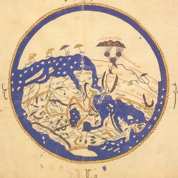
The Entertainment for he who longs to travel the world was an Arabic geographical book written in Sicily in 1154 by the Muslim scholar Al-Sharif al-Idrisi. It was commissioned by the island’s Norman ruler, King Roger II, and drew on Greek, Islamic and Christian knowledge in creating one of the greatest medieval compendiums of geographical knowledge. The book contained seventy regional maps, and began with this exquisite circular world map, oriented with south at the top. Most early Islamic world maps were oriented this way because many of the communities that first converted to Islam in the seventh and eighth centuries lived directly north of Mecca, leading them to regard south as the correct direction of prayer. The earth is encircled by sea and surrounded by fire, an idea taken from the Koran. Particularly noticeable is the vast African continent, dominated by the mountains believed to be the Nile’s source, a sketchy Europe (though with an unsurprisingly large Sicily), and the Arabian Peninsula right in the middle.